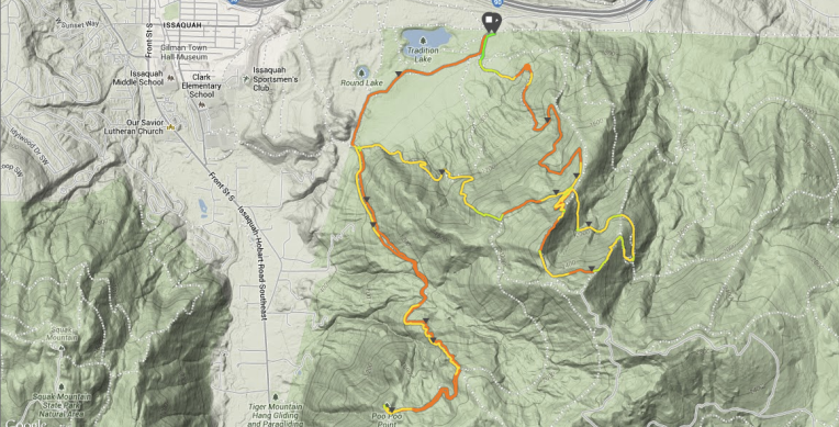
Tiger Mountain State Forest, established in 1981, sits squarely in the middle as the third “Mountain” in the line of the Issaquah Alps. Actually comprised of six separate peaks, the West Tiger #3 summit captures some of the highest foot traffic of all Washington trails. While logging once prevailed throughout the late 1800’s and early 1900’s, the industry has since vanished, moving farther from the ever increasing population dense cities. Nature and trails have replaced the old logging routes served by the “Wooden Pacific” steam donkey engines which lowered tramcars full of felled trees upwards of 5000 feet down the mountain. These operations of the past are still present though as old remnants still dote the mountainside – the remains of an old train wreck, an abandoned bridge with grooves worn into the underside by the tramcar cables and a site on west side of the mountain named for the sound steam whistles would make, Poo Poo Point. This 12.5 mile, 4,450 feet of vert and 3 hours and 40 minutes of a convoluted route covered all those.
I thought I had procrastinated enough to let the isolated and concentrated rain cell move past, but realized on the drive out that wouldn’t be the case. A light drizzle made my decision to wear my slightly new rain jacket, the Patagonia Houdini jacket, hard. It wasn’t a downright rain, but it wasn’t exactly dry either. I opted to put the jacket on, started running and within a quarter mile, took it off. It wasn’t that cold or wet out. I live the in the Pacific Northwest. I can take this. Then the classic Northwest January weather turned and reminded me where I hail from – literally. Nature said, “You can’t fool me, you native Midwesterner! Here’s some hail to remind you that I’m fickle and can change in an instant!”
And with that a light session of baby pea sized hail provided me the opportunity to rethink the use of my rain jacket, so I did. Baby peas turned into teenager peas, the hood went up over my head, and I stopped briefly to take it all in. As teenagers tend to flock in groups, they tend also to move in and move out quickly, leaving all a mess in their wake and this batch of teenage sized hail was no different. The trail turned white, ice covered tree limbs, a fog settled into the dense maturing, but still second (third?) growth forest, and what little wildlife there was took shelter leaving me to run on the stark eerily silent trail.
After reaching Summit #3 and working my way down to the West Tiger Railroad Grade trail, a reclaimed logging tramcar route, I accidentally lolypopped back to West Tiger Trail #3 only realizing after retracing a half mile of my steps where I actually was, wasn’t where I was trying to go. (Yes, I got lost again. No, it’s not my fault this time.) It was the maps and trail signs I swear. Not. Me.
On to Poo Poo Point with a steep ascent, but the payoff is worth it. The incredible view stretches from Tacoma to the southwest to Squak and Cougar Mountain directly west and Issaquah to the northwest in front of the surprisingly large Lake Sammamish. During afternoons of more pleasant weather, Poo Poo Point is the take-off point for paragliders searching for a steady stream of air close in proximity to Seattle.
The run had lots of elevation, almost to a fault, with the steepness providing less uphill running than I’d like, but lots of power-hiking, which I guess is an acceptable trade-off for now. It was a good quad workout and the opportunity to practice with gear and weather I don’t run in on a daily or even weekly or really even monthly basis. While it’s a good, quiet, not too busy run when inclement weather is present with more incoming, the sun on it’s downward path, and you find yourself on seldom used trails, it is probably left to the throngs of city-dwellers looking for a quick escape when any one of those adverse conditions are absent.

